Multiple weather alerts are in effect as a storm system crosses central NC. What to know
READ MORE
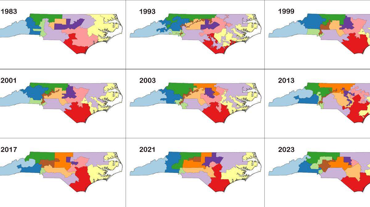
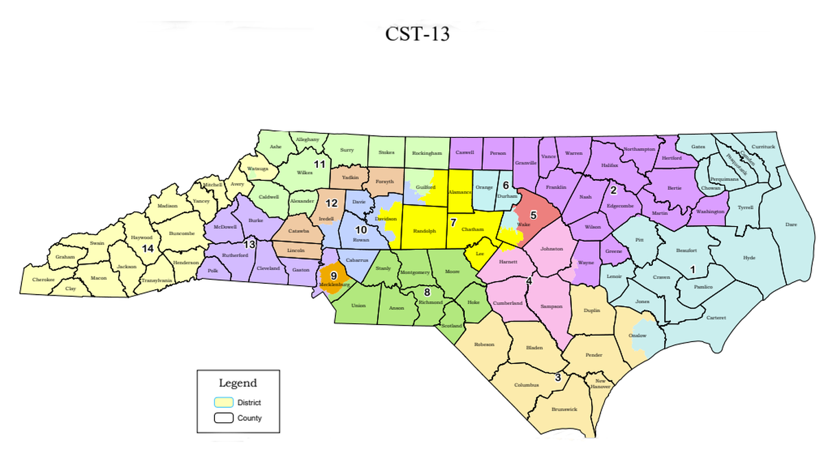
Maps Under the Microscope
At least once a decade, state lawmakers rebuild North Carolina’s election maps. This process of redistricting carries a set of rules. But those rules – and how well mapmakers follow them – get intense scrutiny from the courts almost as soon as the maps become law. This is The N&O’s special report: “Political Maps under the Microscope.”
Expand All
Gerrymandered or no? How will courts judge new North Carolina political maps?

A guide to the three gerrymandering lawsuits challenging NC’s political maps
Meet the judges who could soon rule on North Carolina’s redistricting lawsuits
Podcast: Explore North Carolina’s long history of gerrymandering election maps
Want to design NC redistricting maps? Here’s an app to draw your own political lines.
A storm system is moving across central North Carolina, bringing the potential for flooding and wintry weather to parts of the region on Monday, Jan. 3.
While powerful winds pose risks across the area, snowfall is expected to stay north of U.S. Highway 64 and near the Virginia state line, according to the National Weather Service.
As of 10:20 a.m., forecasters reported sleet in parts of Durham and Wake counties. In Raleigh, the chance for snow is mainly until 4 p.m., with “little or no” accumulation expected.
Across the Triangle, “snow may be briefly heavy with large flakes,” the weather service wrote in a Twitter post. “Some minor accumulation is possible on elevated and grassy surfaces. Roads should remain wet or briefly slushy.”

But the wintry weather risk doesn’t end the afternoon of Jan. 3. The region could see black ice on roads as temperatures drop overnight, according to a National Weather Service video.
Also in central North Carolina, the weather service issued a flood warning for Durham, Orange, Wake and nearby counties until 3 p.m. Forecasters have warned of the potential for runoff and uprooted trees in drenched areas.
“Flooding of rivers, creeks, streams, and other low-lying and flood-prone locations is occurring,” forecasters said.
As of noon, Raleigh-Durham International Airport recorded 2.16 inches of rain. That breaks a record set in 1992, when 1.74 inches fell.
A severe thunderstorm warning that had been issued for Wake, Johnston and other nearby counties has expired. But across central North Carolina, a wind advisory is still in effect until 4 p.m. as forecasters warn of gusts up to 45 mph, damaged tree limbs and power outages.
To the north, winter weather advisory is in effect for Granville and Person counties. The alert is set to expire at 4 p.m.
As cold air moves into the region, those areas could see a mix of rain and snow before it lightens up, according to the National Weather Service and ABC11, The News & Observer’s media partner. Forecasters expect snowfall amounts to be between a dusting and “2 inches of wet slushy snow, mainly on grassy areas.”
The potential for severe weather prompted Wake County to temporarily pause COVID-19 testing and Orange County to delay the service until 1 p.m. Meanwhile, the N.C. Department of Health and Human Services closed three area testing sites until Jan. 4, The News & Observer reported.
Also as a result of weather, Chapel Hill-Carrboro and Orange County school districts canceled classes.
By 9:20 a.m., thousands of Triangle-area residents were without power, according to the N&O.
Across the state, about 10,000 people living in the Charlotte area also had no electricity. Small hail and powerful winds were expected in the region, McClatchy News reported.
Further west, a winter storm warning was issued in the mountains, which were expected to see up to 4 inches of snow.

On Jan. 3, Raleigh is expected to see temperatures stick around 37 degrees during the day before dropping to a 23-degree overnight low. Conditions should warm up the next day, when the forecast high is 45 degrees.
This story was originally published January 3, 2022 at 7:55 AM.
